
Vaizdas:Hanse-Orden.png
Pradinė rinkmena (1 263 × 753 taškų, rinkmenos dydis: 210 KiB, MIME tipas: image/png)
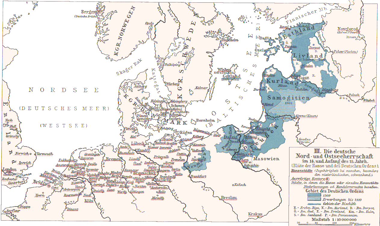
- Hanse cities underlined in red.
- Ordensstaat possessions until 1410 marked in blue colors, with year of acquisition.
- Lands of the bishoprics are marked with first letter:
- Pomesanien, Kulm (Km.), Ermland, Samland in Prussia
- Riga, Kurland, Ösel, Dorpat in the North East
- Towns of Hanseatic League are underlined in red.
Originally from 1901 edition of Putzgers Historischer Schul-Atlas and uploaded to Hanse.jpg as 100+ year old Public Domain by de:Benutzer:Olbertz. Improved quality and reduced file size by Matthead. See also at maproom.org
|
Šis failas yra viešo naudojimo tose šalyse, kuriose autorių teisės galiojimo netenka po 70 metų nuo autoriaus mirties.
| |
| This file has been identified as being free of known restrictions under copyright law, including all related and neighboring rights. | |
Rinkmenos istorija
Paspauskite ant datos/laiko, kad pamatytumėte rinkmeną tokią, kokia ji buvo tuo metu.
| Data/Laikas | Miniatiūra | Matmenys | Naudotojas | Paaiškinimas | |
|---|---|---|---|---|---|
| dabartinis | 23:31, 2 gruodžio 2007 | | 1 263 × 753 (210 KiB) | Matthead | |
| 10:08, 2 gruodžio 2007 |  | 1 263 × 753 (219 KiB) | Matthead | This map depict the extension of Hanseatic League cities and Teutonic Order lands (blue) in 14th and earl y15th century. Originally from 1901 edition of Putzgers Historischer Schul-Atlas and uploaded to [http://de.wikipedia.org/wiki/Bild:Hans |
Rinkmenos naudojimas
Šis puslapis naudoja šią rinkmeną:
Visuotinis rinkmenos naudojimas
Ši rinkmena naudojama šiose viki svetainėse:
- Naudojama af.wikipedia.org
- Naudojama be-tarask.wikipedia.org
- Naudojama de.wikipedia.org
- Naudojama en.wikipedia.org
- Naudojama et.wikipedia.org
- Naudojama frr.wikipedia.org
- Naudojama fr.wikipedia.org
- Naudojama sv.wikipedia.org
- Naudojama uk.wikipedia.org