
Vaizdas:Europe 1878 map de.png
Šios peržiūros dydis: 800 × 526 taškų. Kitos 5 rezoliucijos: 320 × 211 taškų | 640 × 421 taškų | 1 024 × 674 taškų | 1 280 × 842 taškų | 2 284 × 1 503 taškų.
Pradinė rinkmena (2 284 × 1 503 taškų, rinkmenos dydis: 1,01 MiB, MIME tipas: image/png)
Aprašymas
| Aprašymas |
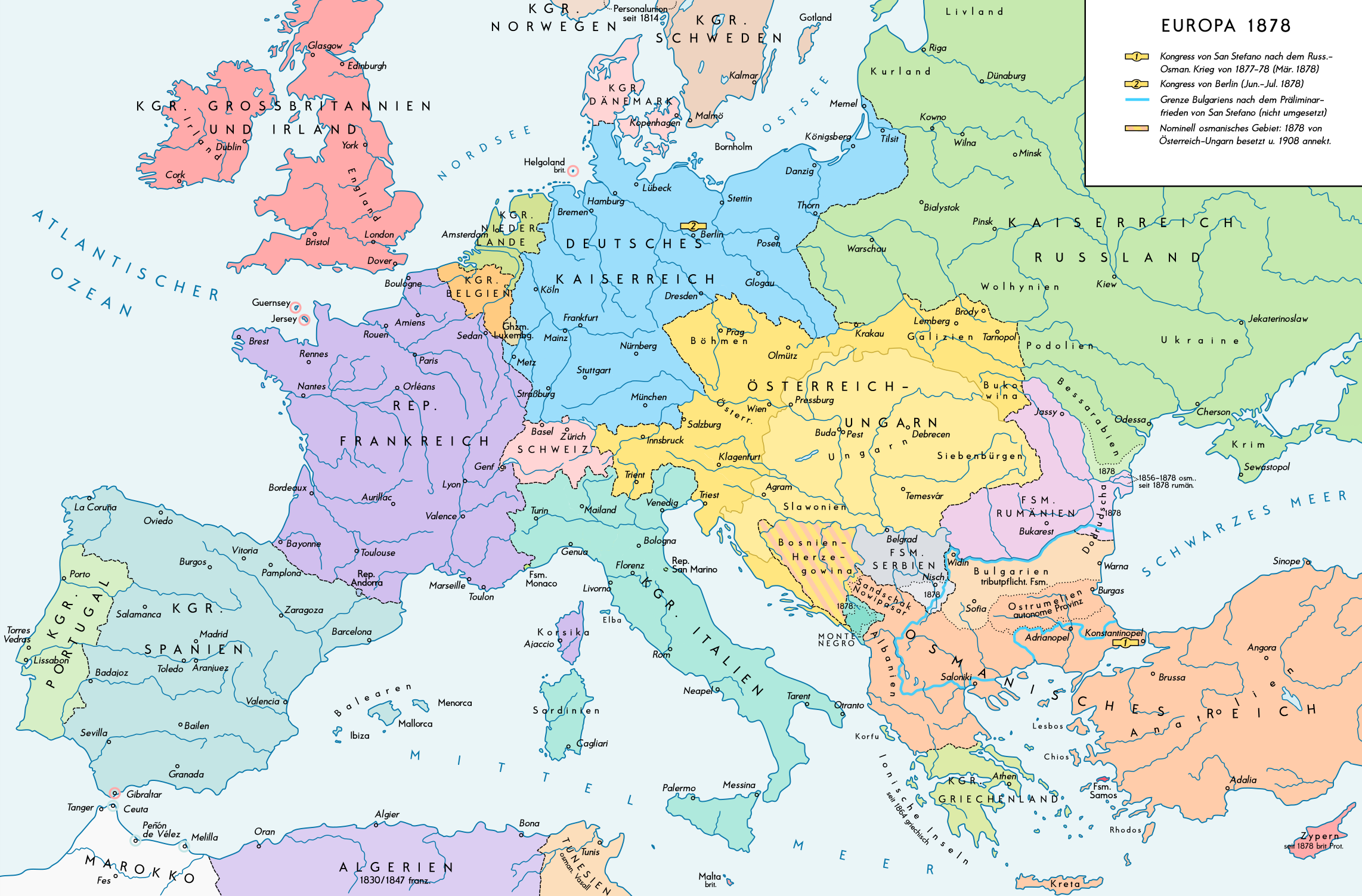
English: Europe 1878. Historical map of the political situation after the Congress of Berlin and the territorial and political rearrangement of the Balkan Peninsula. Please don't alter the map, when you think there something not written or depicted correctly. Leave a message at the talk page of the file. After a verificiation and a possible discussion, i will upload a new map version with all new changes. This prevents an unnecessary waste of disc space and ensures a good result, aesthetically and contentwise. - The author. Deutsch: Europa 1878. Historische Karte der politischen Situation nach dem Berliner Kongress und der politischen und territorialen Neuordnung des Balkans. Bitte die Karte bei Änderungs- und Korrekturwünschen nicht selbst verändern, sondern eine Anmerkung im Diskussionsbereich der Bilddatei hinterlassen. Nach einer Prüfung und ggfs. Diskussion werden evtl. Änderungen von mir zusammengefasst eingearbeitet. Das vermeidet unnötige Speicherplatz-Verschwendung und gewährleistet ein ästhetisch ansprechendes und inhaltlich korrektes Ergebnis. - Der Urheber. |
| Data | |
| Šaltinis |
Mano darbas. Source of Information: Historical atlases and maps – Ramsay Muir, George Philip (ed.): Philip's New School Atlas of Universal History, George Philip & Son, Ltd., London 1928 – Dr. Walter Leisering (ed.): Putzger Historischer Weltatlas, Cornelsen Verlag, Berlin 1992, ISBN 3-464-00176-8 – Bayerischer Schulbuch-Verlag (ed.): Großer Historischer Weltatlas, Dritter Teil, Neuzeit, Bayerischer Schulbuch-Verlag, München 1981, ISBN 3-7627-6021-7. – Prof. Dr. Vadim Oswalt u. Prof. Dr. Hans Ulrich Rudolf (ed.): Klett-Perthes Atlas zur Weltgeschichte, Ernst Klett Verlag, Stuttgart 2011, ISBN 978-3-12-828194-0 |
| Autorius | Alexander Altenhof |
| Kitos versijos |
|

Recompressed without quality loss with OptiPNG (1.28 MB > 1.00 MB)
Licencija
Aš, šio darbo autoriaus teisių savininkas, publikuoju jį su šia licencija:
This file is licensed under the Creative Commons Attribution-Share Alike 4.0 International license.
- Jūs galite:
- dalintis – kopijuoti, platinti bei persiųsti šį darbą
- pri(si)taikyti – adaptuoti darbą
- Su šiomis sąlygomis:
- autoriaus nurodymas – Turite pateikti atitinkamą kreditą, pateikti nuorodą į licenciją ir nurodyti, ar buvo atlikti pakeitimai. Tai galite padaryti bet kokiu būdu, bet ne taip, kad licencijos išdavėjas patvirtintų jus ar jūsų naudojimą.
- dalinkis panašiai – Jei perdirbsite, redaguosite ar atkursite šį darbą, jį galėsite platinti tik su tokia pačia ar panašia į šią licencija.
Rinkmenos istorija
Paspauskite ant datos/laiko, kad pamatytumėte rinkmeną tokią, kokia ji buvo tuo metu.
| Data/Laikas | Miniatiūra | Matmenys | Naudotojas | Paaiškinimas | |
|---|---|---|---|---|---|
| dabartinis | 23:53, 14 balandžio 2017 | | 2 284 × 1 503 (1,01 MiB) | KaterBegemot | Minor changes |
| 22:35, 10 rugsėjo 2016 |  | 2 284 × 1 503 (1 023 KiB) | KaterBegemot | {{Information |Description ={{en|1=Europe 1878. Historical map of the political situation after the Congress of Berlin and the territorial and political rearrangement of the Balkan Peninsula.<br> ''Please don't alter the map, when you think there so... |
Rinkmenos naudojimas
Šis puslapis naudoja šią rinkmeną:
Visuotinis rinkmenos naudojimas
Ši rinkmena naudojama šiose viki svetainėse:
- Naudojama de.wikipedia.org
- Naudojama lt.wikipedia.org
- Naudojama zh.wikipedia.org